
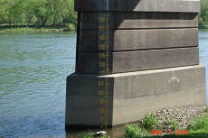
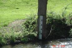
MONTGOMERY RIVER LEVEL EVENT CHART
(in feet)
11.0
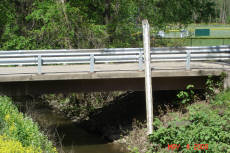
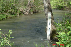
Begin reading staff gauge at Montgomery Little League Bridge
15.0 Water at top of river bank
15.0
Advise Little League officials of possible water damage
15.0
Advise Riverside Campground owner of water level
16.0 CAUTION STAGE
16.0
Post water levels on Borough Website
17.0 Water in Little League building - Little League Bridge closed
18.0 Water at 1st campsite at Riverside Campground
20.0 FLOOD STAGE
20.0
Advise Residents of Broad and Second Street of water level
20.0
Open Emergency Operation Center at Borough Office
20.0 Water covers road at old RR Underpass on S. Main Street
22.0 Water on gauge next to post office. 2' on roadway at underpass
22.0
Respond
EMA Mobile Command Truck to Muncy River Bridge
22.6 MUNCY RIVER BRIDGE CLOSES
22.9 Water in Montgomery Park Pavilion - Water across Ellis Parkway
24.5 Water in basement of former Baptist church at 19 W Houston Ave
24.8 Water over road at Montgomery Bridge - Route 405
25.0 Water at base of carnival ground concession stand
25.0
Advise Sewer Plant manager of water level
25.0 Water around Riverside Lounge and upper campground
25.1 Water across road at Broad and 2nd Street
25.7 MONTGOMERY RIVER BRIDGE CLOSES
26.9 Water across road at bridge on West Houston Avenue
27.0 Water inside Riverside Lounge
30.0
Prepare to shelter Bower Street Development residents
30.4 Water across road at Montgomery Street and Thomas Avenue
31.0 Water around buildings at Borough Garage and Post Office
31.4 Water on first floor of 10 Broad Street
33.0 Water on first floor of Bower Street development
Keep in mind that the river readings change constantly. If you are in one of the areas subject to flooding, keep informed of the river readings. In 1972 during Hurricane Agnes, the river rose to an astounding crest of 37.45 feet. That was 17.45 feet above flood stage in Montgomery Borough.

Montgomery Emergency Management
Borough of Montgomery, Lycoming County, PA